The Patna Ring Road Map is a comprehensive guide to the planned and under-construction circular highway that will encircle Patna city, reducing congestion, improving connectivity, and spurring development across Bihar. This article covers route details, phase-wise construction, villages affected, land acquisition status, timelines, benefits, real estate impact and latest project updates for residents and investors.
Featured Snippet: The Patna Ring Road Map shows a proposed outer-ring alignment around Patna connecting major highways and key nodes like Bihta, Danapur, Punpun and Hajipur. Designed in phases, it aims to cut through-traffic, shorten travel times and unlock land for residential and commercial growth.
Table of Contents
- Patna Ring Road Overview
- Patna Ring Road Map
- Complete Route Overview
- Districts Covered
- Villages Covered
- Entry & Exit Points
- Phase-wise Construction
- Latest Project Updates
- Government Plans
- Land Acquisition Status
- Benefits for Patna
- Benefits for Bihar
- Connectivity Improvements
- Travel Time Reduction
- Economic Impact
- Real Estate Impact
- Investment Opportunities
- Comparison with Other Ring Roads
- Common Questions
- Expert Insights
- Future Scope
- Summary
- Conclusion
- FAQs
Patna Ring Road Overview
The Patna Ring Road is planned as an outer orbital route to divert long-distance and heavy vehicle traffic away from Patna's inner roads. It integrates with national and state highways and connects growth nodes like Bihta, Danapur and Hajipur. The project is being implemented in phases by state agencies with technical inputs from central authorities. Exact alignments, timelines and land acquisition figures are updated periodically by the Bihar Government and related agencies.
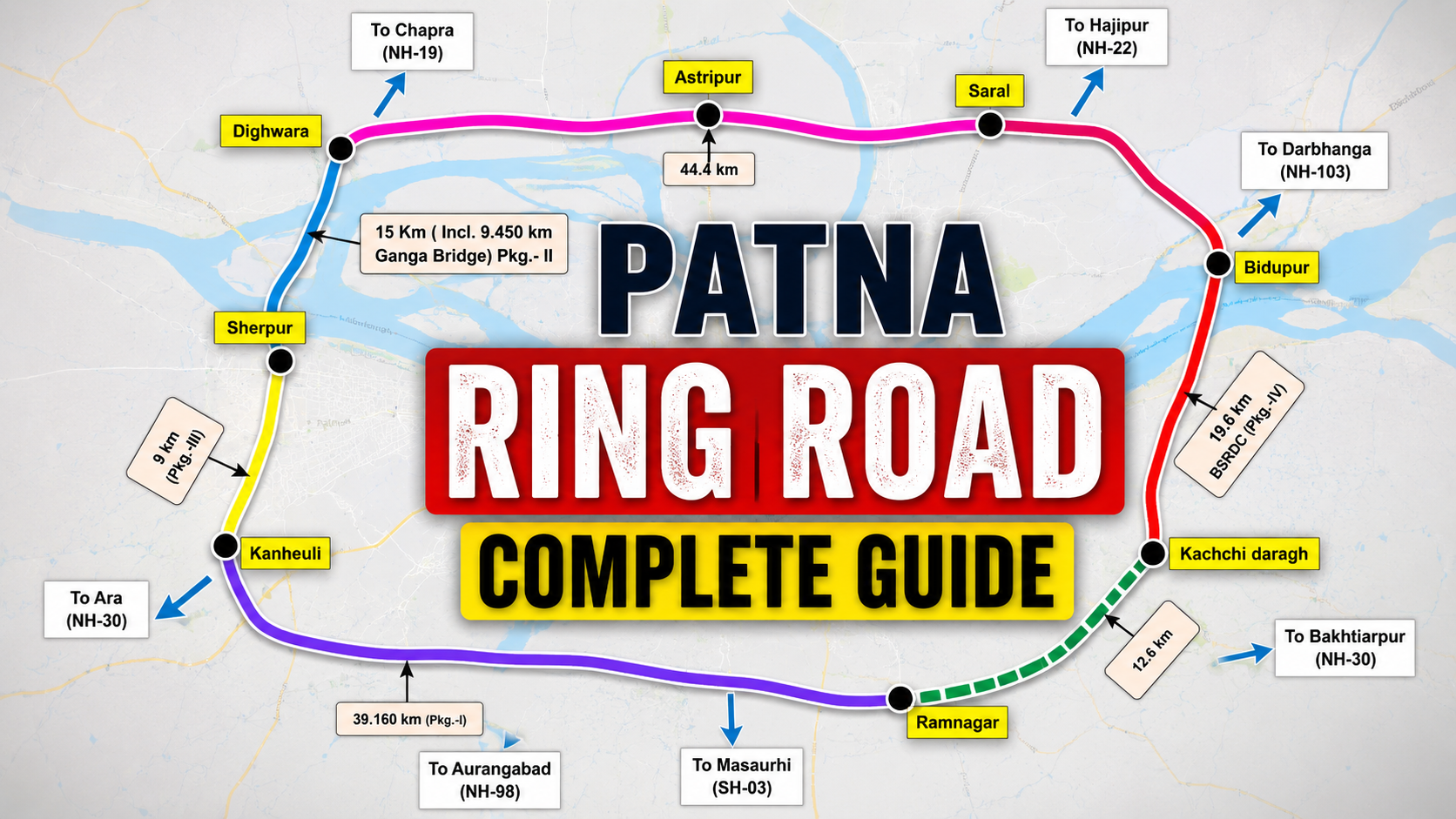
Patna Ring Road Map Explained
The Patna Ring Road Map explains alignment, interchange points, service roads, and bypasses. Different map releases show slight alignment changes to minimize land acquisition, environmental impact, and to connect strategic development zones such as Bihta Master Plan and Patna Master Plan. Map versions may include downloadable PDFs released by authorities—search "Patna Ring Road PDF" on official portals for the latest maps.
Complete Route Overview
This section summarizes the ring road's likely route. Exact kilometers and connecting junctions depend on final approvals and land availability.
| Section | Details |
|---|---|
| Approximate Length | ~80–100 km (subject to final alignment) |
| Primary Nodes Connected | Bihta, Danapur, Punpun, Phulwari, Hajipur, Bakhtiyarpur corridor |
| Connection to Highways | NH-19, NH-22, state highways and local arterial roads |
| Design Elements | 4/6-lane carriageway, interchanges, service roads, overbridges |
Districts Covered
The ring road alignment crosses multiple districts around Patna. Precise districts depend on the final route; the likely list is below.
| District | Role |
|---|---|
| Patna | Main urban node and several suburbs |
| Vaishali | Connectivity towards Hajipur and NH links |
| Arwal/ Bhojpur (fringe) | Peripheral connectivity depending on north/south alignment |
Villages Covered
Alignment passes near and through multiple villages. Authorities publish official village lists during land acquisition notices. For project planning and compensation queries, check notices issued by the Bihar Government and Patna Development Authority.
| Section | Representative Villages (Examples) |
|---|---|
| Western stretch near Bihta | Villages around Bihta and Phulwari |
| Southern stretch | Punpun-adjacent villages |
| Northern stretch towards Hajipur | Vaishali-border villages |
Entry & Exit Points
Entry and exit points are planned at major highway junctions and growth nodes to ensure seamless connectivity. Typical locations include junctions near Bihta (for NH connections), Danapur, Phulwari, and the Hajipur corridor. The final map will show grade-separated interchanges at busy intersections to optimize traffic flow.
Phase-wise Construction
Project execution is expected in multiple phases to manage funding, land acquisition, and construction logistics. Phased work allows sections to open earlier to traffic while other parts undergo construction or land clearance.
| Phase | Focus | Key Features |
|---|---|---|
| Phase 1 | Priority linkages (e.g., Bihta to Danapur) | Initial 20–40 km, 4/6 lanes, interchanges |
| Phase 2 | Extend ring to northern and eastern segments | Land acquisition, bridges, river crossings |
| Phase 3 | Final connections and service roads | Completes loop, ancillary infrastructure |
Latest Project Updates
Stay updated through official press releases by Bihar Government, Patna Development Authority, and Bihar State Road Development Corporation. Updates typically include revised alignments, contractor appointments, tender awards, and land acquisition notices. Some specifics may change and should be verified from official sources.
Government Plans
Government emphasis is on integrated planning that meshes the ring road with city masterplans, logistics hubs, and industrial nodes. Key government bodies involved include the Patna Development Authority, Bihar Government departments, and central agencies for funding and technical oversight. Collaboration with entities like NHAI may be sought for technical and financing support.
Land Acquisition Status
Land acquisition is often the longest lead item in such projects. Notices for acquisition, compensation details, and resettlement plans are published by state authorities. Affected landowners must follow official channels; details often appear in local district collector notifications and government gazettes. If land acquisition details are uncertain, verify from district authorities or official PDFs.
Benefits for Patna
- Decongestion of inner-city roads by diverting through-traffic.
- Improved air quality in central neighborhoods due to reduced traffic.
- Enhanced last-mile connectivity to new development nodes.
- Better public transport integration and bus rapid transit possibilities.
Benefits for Bihar
- Regional economic growth via improved freight movement.
- Attracts investment in manufacturing, warehousing and logistics.
- Supports development of peri-urban townships and industrial corridors.
Connectivity Improvements
The ring road will connect to national highways and regional corridors, easing travel between Patna and neighboring districts and beyond. Integration with projects like IIT Bihta and Patna Metro (where applicable) will create multimodal transport benefits and planned urban expansion zones.
Travel Time Reduction
By providing an orbital route, the Patna Ring Road aims to reduce travel time between peripheral nodes significantly. Typical travel-time savings depend on congestion levels; for many cross-city trips, expect reductions in travel time by 20–50% once major sections open, especially for heavy vehicles bypassing city center.
Economic Impact
Ring roads catalyze industrial parks, logistics hubs and residential townships. Lower transport costs and faster goods movement improve competitiveness for local businesses. Tax revenue and employment opportunities usually rise during construction and after project completion due to new commercial activities.
Real Estate Impact
Areas along the ring road typically see appreciation in land and property values. Early investors and developers often target land parcels near planned interchanges for residential and commercial projects. However, investors should verify approvals, land titles, and future zoning in official documents before buying. For nearby masterplan context see Bihta Master Plan and Bihta Property Price.
Investment Opportunities
- Plots and land parcels near interchanges for residential or commercial development.
- Logistics and warehousing sites along highway access points.
- Retail and service hubs at planned nodes and market towns.
Comparison with Other Indian Ring Roads
Like other major ring roads (e.g., Lucknow Ring Road, Jaipur Ring Road), Patna's ring road aims to balance urban decongestion and regional connectivity. Key differentiators will be local topography, river crossings (Ganges tributaries nearby), land acquisition complexity, and integration with Bihar's specific development plans.
Common Questions
Below are frequently asked project-level questions. For precise technical and legal details refer to government releases and district collector offices.
Expert Insights
From an infrastructure planning viewpoint, the Patna Ring Road should prioritize:
- Clear interchanges at major highways to avoid future bottlenecks.
- Service roads and access management to protect local traffic flow.
- Dedicated corridors for freight to separate slow-moving local traffic.
- Environmental and social safeguards for sustainable implementation.
Future Scope
Future possibilities include expansion to expressway standards, dedicated public-transport lanes, logistics parks, and transit-oriented development nodes. Long-term planning should align ring road land use with Patna's masterplan and regional growth strategies to maximize benefits.
Summary
The Patna Ring Road Map is a transformational infrastructure project intended to reroute through-traffic, boost connectivity, and unlock economic growth around Patna. Delivered in phases, the project requires coordinated land acquisition, funding and design efforts. Investors and residents should track official updates for precise alignments, timelines and compensation details.
Conclusion
The Patna Ring Road will be a pivotal piece of Bihar's transport infrastructure. For homebuyers, investors and planners, understanding the Patna Ring Road Map—its phases, route, village impacts, and timelines—is essential before making decisions. Always verify key facts from official government notifications and project PDFs to make informed choices.
Frequently Asked Questions (FAQs)
1. What is the Patna Ring Road Map?
The Patna Ring Road Map shows the proposed outer orbital route around Patna connecting major highways and nodes like Bihta, Danapur and Hajipur. It outlines phase-wise alignments, interchange locations, and service roads to decongest city traffic and boost regional connectivity.
2. Where can I find the official Patna Ring Road PDF map?
Official PDFs are usually published by the Bihar Government, Patna Development Authority or district collectorate websites. Check government portals, tender documents and official press releases for the latest downloadable maps and gazette notifications.
3. How many phases does the Patna Ring Road have?
Implementation is planned in multiple phases to manage land acquisition and funding. Typical plans show Phase 1 as priority stretches, followed by Phase 2 and Phase 3 to complete the full loop. Exact phase definitions and lengths are subject to official updates.
4. Which districts and villages does the ring road pass through?
The alignment passes through Patna and nearby districts (e.g., Vaishali) and several peripheral villages near Bihta, Danapur and Hajipur. Official village lists are published during the land acquisition process—verify from district notifications.
5. How will the ring road affect property prices?
Property values near planned interchanges and along the ring typically appreciate due to improved connectivity and development potential. Buyers should confirm zoning, clear titles and infrastructure timelines before investing.
6. What is the current land acquisition status?
Land acquisition updates are issued by local authorities and can vary by section. Check district collector notices, government gazettes and Patna Development Authority updates for the latest acquisition and compensation information.
7. Will the Patna Ring Road reduce travel time?
Yes—once major sections open, through-traffic can bypass the city, reducing travel times significantly for cross-city and inter-district trips. Exact savings depend on final alignment and traffic volumes.
8. Who is funding and implementing the project?
Funding and implementation typically involve the Bihar Government, state agencies such as the Bihar State Road Development Corporation, and potential central assistance or technical support from bodies like NHAI. Funding details are announced in official releases.
9. How can I check if my village is affected?
Check district collectorate notifications, local land acquisition notices, and official gazettes. Public hearings and stakeholder meetings are usually announced before final acquisition decisions.
10. Are there environmental or social safeguards?
Major infrastructure projects include environmental impact assessments and resettlement/compensation plans. These details are disclosed in project reports and EIA documents; verify them with the implementing agency.
11. How will the ring road integrate with other projects?
Integration with the Patna Master Plan, Bihta development, and transit projects like Patna Metro is planned to maximize multimodal connectivity. Exact linkages will appear in coordinated development plans and technical reports.
12. Where can investors get reliable updates?
Reliable updates come from Bihar Government releases, Patna Development Authority, district collectorate notices and official tender documents. Cross-check media reports with official PDFs and gazette notifications before decisions.