If you have ever tried to buy land on the outskirts of Patna, you have probably heard someone mention the Patna Master Plan 2031 at some point during the conversation, usually right before the broker changes the subject. That is not an accident. The Master Plan is the single document that decides whether a plot can legally carry a house, a shop, or nothing at all for the next several years, and most buyers never actually read it.
This guide walks through what the plan says, how Patna's zones are laid out, which corridors are seeing real construction activity, and where the gaps in public information still exist. Wherever the details are genuinely unclear or subject to change, that is stated plainly, because guessing on a land-use question is how people end up owning property they cannot build on.
About Patna Master Plan 2031
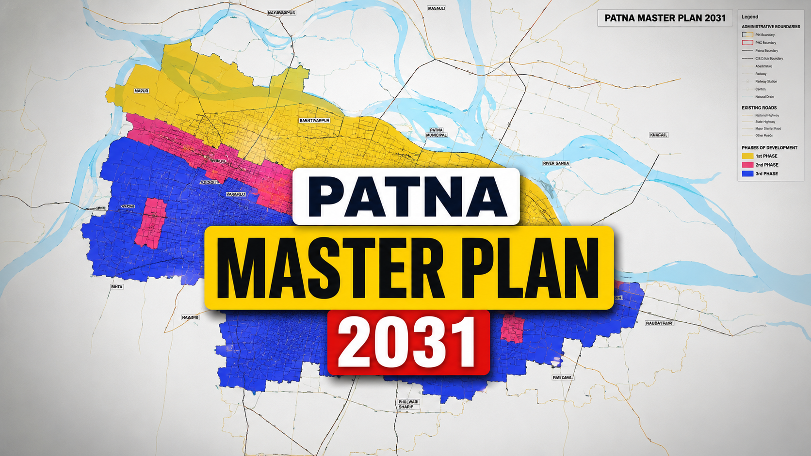
The Patna Master Plan 2031 is Bihar's statutory land-use and infrastructure blueprint for the Patna Planning Area, approved by the state cabinet in October 2016 after Patna went without an active master plan for over three decades. It classifies land into residential, commercial, industrial, and agricultural zones, and guides development of roads, the metro, the ring road, and the Bihta airport up to the year 2031.
Table of Contents
- What is Patna Master Plan 2031?
- Why Patna Needed a New Master Plan
- A Short History of Patna's Planning Efforts
- Who Prepared the Plan and Who Implements It
- Patna Planning Area: Boundaries and Population
- Land Use Classification Explained
- Residential Zones
- Commercial Zones
- Industrial Zones and the Dumri IT Park
- Mixed Use and Urban Centres
- Village Settlement and Agriculture Zones: The CLU Trap
- Transportation Development
- Patna Ring Road
- Patna Metro
- Road and Highway Network
- Bihta Airport
- Green Zones, Water Bodies and Public Utilities
- Healthcare and Education Infrastructure
- Growth Corridors and Areas Likely to Benefit
- Real Estate Impact and Investment Considerations
- Villages Covered Under the Plan
- Who Benefits From the Master Plan
- Challenges in Implementation
- Government Initiatives Supporting the Plan
- Common Myths About the Master Plan
- Practical Tips Before You Buy Land in Patna
- Key Takeaways
- Frequently Asked Questions
- Final Thoughts
What is Patna Master Plan 2031?
The Patna Master Plan 2031 is the statutory document that governs how land can be used across the Patna Planning Area. Every plot inside that boundary carries a designation under the plan, whether it is marked for housing, shops, factories, agriculture, or something else entirely. Building outside your plot's designated use without approval is what planning departments call an unauthorised development, and it is the single biggest legal risk buyers face in Patna's outer belt.
The plan was prepared under Bihar's Urban Development and Housing Department, with the draft consultancy handled by DCPL, Kolkata, and later revised and updated by CEPT University, Ahmedabad. It was drafted as a revision of the earlier Patna Master Plan 2021, extending the planning horizon to 2031. The Bihar cabinet gave its formal approval to the plan in October 2016.
Why Patna Needed a New Master Plan
To understand why this document matters so much, you need to look at what happened before it existed. Patna did not have an active master plan since 1981. For roughly 35 years, the city grew without a statutory framework guiding where roads, drains, and residential blocks should go.
That gap did not mean nothing was built. It meant everything was built without coordination. Colonies came up on farmland with no road-widening reserved. Drains were never planned for. Water bodies got encroached because there was no zoning document telling anyone they were protected. Patna had no operational masterplan from 1981 to 2016, and during those 35 years, unplanned construction crept across agricultural and rural land across the city's periphery.
The 2031 plan exists to reverse that pattern. It sets zoning rules, reserves road corridors, plans utility networks in advance, and gives the state a legal basis to say no to construction that does not fit the designated land use.
A Short History of Patna's Planning Efforts
Patna's planning story goes back further than most residents realise. Early planning intervention traces to a notification dated 20th June 1967, issued through the Patna Improvement Trust. That Trust, however, did not have adequate infrastructure or legal support to implement the plan it was handed.
The Trust was eventually disbanded, and the Patna Regional Development Authority (PRDA) was set up in 1975 and formed in 1979 to take over regional and master planning duties. After the Bihar Municipal Act of 2007 came into force, the PRDA was merged into the Patna Municipal Corporation, and its planning role eventually passed to a new body created specifically for this plan: the Patna Metropolitan Area Authority.
Who Prepared the Plan and Who Implements It
Three institutions matter here, and confusing them is a common mistake among first-time buyers.
The Urban Development and Housing Department (UDHD), Government of Bihar, is the state department that owns the plan. DCPL Kolkata and CEPT University Ahmedabad were the technical consultants who drafted and revised the document. And the Patna Metropolitan Area Authority (PMAA) is the body actually responsible for day-to-day implementation. PMAA was constituted for the purpose of implementing Patna Master Plan 2031, exercising powers granted under Section 11 of the Bihar Urban Planning and Development (BUPD) Act, 2012.
If you need to check a plot's zoning status, verify a Change of Land Use application, or confirm a recent notification, PMAA is the correct authority to approach, not the old PRDA, which no longer functions in this capacity.
Patna Planning Area: Boundaries and Population
The Patna Planning Area is considerably larger than most people imagine when they think of "Patna." The Government of Bihar formally notified this metropolitan region on 13 August 2014, replacing the earlier PRDA jurisdiction. The region spans about 1,167.04 square kilometres and had an estimated population of 3,874,000 as of 2021, and it extends beyond Patna district to include parts of Vaishali and Saran districts.
According to planning consultancy documentation reviewed during the master plan revision, the wider planning area draws in 15 community development blocks from Patna district, of which five fall fully inside the area and ten only partially, along with three CD blocks from Saran district falling partially inside and three from Vaishali district falling fully inside the boundary.
Population projections used to size the plan's infrastructure demand tell their own story. The total population of the planning area was recorded at roughly 20.5 lakh in 1991, growing to around 28.7 lakh by 2001, with projections putting it near 38 lakh by 2011, 48 lakh by 2021, and just over 60 lakh by 2031. Whether the city actually hits that final figure depends on the next Census, but the trajectory explains why so much of the plan is built around accommodating fast urban growth on the periphery rather than the core.
Population and Growth Snapshot
| Year | Projected Population (approx.) | Urban Decadal Growth Rate |
|---|---|---|
| 2001 | 28.7 lakh | 32.5% |
| 2011 | 38 lakh | 26.9% |
| 2021 | 48.3 lakh | 24.7% |
| 2031 (Projected) | 60.2 lakh | Projected |
Figures are drawn from planning-stage projections prepared for the master plan revision. Readers should treat 2031 numbers as planning targets rather than confirmed Census results, since projections of this kind are routinely revised once fresh Census data becomes available.
Land Use Classification Explained
At its core, a master plan is a land-use map with legal teeth. Patna's plan divides the entire planning area into broad categories, each carrying its own set of permitted activities and construction norms. The main categories used are residential, commercial, industrial, public and semi-public use, open space, and transportation.
A plot's classification is not cosmetic. It determines the type of construction you can undertake, the floor area ratio you are entitled to, whether you need environmental clearances, and whether banks will finance a home loan against the property at all. Most home loan rejections on peripheral Patna plots trace back to a zoning mismatch that the buyer never checked before signing.
Broad Land Use Categories Under the Master Plan
| Zone Type | Typical Permitted Use | Key Consideration for Buyers |
|---|---|---|
| Residential | Housing, apartments, group housing | FAR and setback norms apply |
| Commercial | Shops, offices, markets | Usually along major roads and nodes |
| Industrial | Manufacturing, warehousing, IT/ITES | Pollution and buffer norms apply |
| Mixed Use | Combined residential and commercial | Common along Urban Centre corridors |
| Public/Semi-Public | Government offices, hospitals, institutions | Generally not available for private purchase |
| Open Space | Parks, green belts, playgrounds | Construction is restricted |
| Village Settlement/Agriculture | Farming, existing rural habitation | Requires Change of Land Use before development |
Residential Zones
Residential zoning under the plan is concentrated in two kinds of areas: infill zones within the existing Patna Municipal Corporation limits, and expansion zones along the growth corridors radiating outward. Within PMC limits, residential zoning mostly formalises what already exists, densifying colonies that were built before 2016 and regularising them under the new plan.
Along the corridors, particularly the western belt toward Danapur and Bihta, the plan earmarks larger tracts for planned residential development, group housing, and township-style projects. This is the zoning category that generates the most buyer interest, because land here is comparatively cheaper than inside PMC limits but is still recognised for eventual formal development.
Commercial Zones
Commercial land use is concentrated along arterial roads, transit nodes, and the Urban Centres proposed under the multi-nuclei model discussed later in this guide. Boring Road, Bailey Road, Exhibition Road, and the Patna Junction area remain the established commercial cores, while emerging commercial pockets are appearing around metro stations and along the Danapur–Bihta corridor as construction activity picks up.
A practical note for anyone eyeing commercial property: commercial zoning near a metro station or a proposed highway interchange typically carries a valuation premium well before the infrastructure is even complete, purely on anticipated footfall. That premium can just as easily deflate if a project gets delayed, so timeline verification matters more for commercial land than for residential plots.
Industrial Zones and the Dumri IT Park
Industrial land use under the plan is comparatively limited in scale but strategically placed. One of the more concrete allocations to emerge from the plan is the IT Park at Dumri. An area of 17.6 square kilometres in Dumri village, in the Punpun block of the Patna Metropolitan Region, has been allocated for an IT Park.
This kind of allocation matters for the region's employment base, since IT and IT-enabled services zones tend to pull in ancillary commercial and residential demand around them once development actually begins. As of now, readers should verify current construction status of the Dumri IT Park directly with PMAA or the Bihar Industrial Area Development Authority before treating it as an active, built-out project.
Mixed Use and Urban Centres
Rather than spreading growth evenly, the Patna Master Plan 2031 was built around a multi-nuclei model, with Urban Centres proposed along key corridors to pull growth away from the congested core of Patna Municipal Corporation. This is a fairly standard planning technique used across Indian cities facing core congestion, and it explains why so much current construction activity is happening well outside the traditional city centre.
Mixed-use zoning near these Urban Centres typically allows ground-floor commercial activity with residential floors above, a format that has proven popular with mid-size developers because it lets them sell both shop and apartment inventory from a single project.
Village Settlement and Agriculture Zones: The CLU Trap
This is arguably the most important section for anyone actually planning to buy land, because it is where most disputes originate. Large stretches of the Patna Planning Area outside the Patna Municipal Corporation carry an Urban Agriculture or Village Settlement zone designation under the Master Plan 2031, and both classifications require a formal Change of Land Use, commonly abbreviated as CLU, before any residential or commercial development can legally happen.
The problem is that this requirement is rarely disclosed at the point of sale. Brokers selling plots in these zones rarely mention the CLU requirement, and if a seller cannot produce the conversion approval, the buyer ends up with land that cannot legally be built on until the state approves the conversion, which is not guaranteed.
Before paying even a token advance on peripheral land, ask the seller directly for the CLU certificate, and if one does not exist, factor in the real possibility that conversion may take months, involve fees, or be refused outright depending on the parcel's location and current use.
Transportation Development
No part of the master plan draws more public attention right now than transportation, because roads and metro lines are the infrastructure people can actually see being built. Three projects dominate the conversation: the ring road, the metro, and the Danapur–Bihta elevated corridor.
Patna Ring Road
Public reporting on the Patna Ring Road contains genuinely conflicting figures, and honesty about that is more useful than picking one number and presenting it as settled fact.
One set of reports describes a 150 km ring road proposed under the Bharatmala programme, estimated to cost around Rs 15,000 crore, forming a loop covering approximately 1,350 square kilometres and connecting suburban and peri-urban areas around Patna. Under this version, the alignment begins near Kanhauli in Bihta and passes through Naubatpur, Ramnagar, Kacchi Dargah, Bidupur, Hajipur, Sonepur, Dighwara and Sherpur before reconnecting, integrating 12 national highways and five state highways, and including two major bridges across the Ganga. It is planned as a six-lane, access-controlled corridor designed for speeds up to 80 km/h.
A separate, earlier set of reports describes a 137 km ring road estimated at Rs 1,300 crore, with a 25 km Sarai (Vaishali) to Naya Gaon (Saran) stretch approved in August 2025 and the full project targeted for completion by 2028. That version similarly notes the corridor will connect Vaishali and Saran districts while intersecting 12 national highways and five state highways.
The overlap in highway integration numbers suggests these are different reporting snapshots of the same evolving project rather than two unrelated schemes, but the length and cost figures do not reconcile cleanly. On the ground, work is visibly progressing on individual packages. NHAI has opened and reviewed bids for the Sherpur–Kanhouli six-lane stretch, a roughly 10 km segment with a reported cost of ₹777.79 crore. Land acquisition for the Kanhauli–Sherpur stretch has gathered pace, requiring approximately 177 acres, with construction expected to begin after the 2026 monsoon once compensation formalities are completed.
Given the discrepancy in headline numbers, treat the ring road as a live, multi-package project rather than a single fixed plan, and verify the current alignment and package-wise progress through NHAI or PMAA before making any land decision based on proximity to it.
Patna Metro
Unlike the ring road, the metro's numbers are relatively consistent across sources, which makes it easier to summarise with confidence. Patna Metro Phase 1 covers 30.91 km across two lines with 24 stations, developed by Patna Metro Rail Corporation Ltd (PMRCL) with Delhi Metro Rail Corporation acting as General Consultant. The Detailed Project Report was prepared by RITES and approved by the Bihar government on 9 February 2016, central government approval followed on 6 February 2019, and Prime Minister Modi laid the foundation stone on 17 February 2019.
Ground work for Phase 1 began in November 2020, and a 3.2 km priority section connecting Zero Mile and New ISBT was inaugurated in October 2025. As of early 2026, the total network cost stands at approximately Rs 13,365.77 crore, with the Red Line roughly 85 percent complete and the Blue Line around 70 percent complete. Full network operations are officially targeted for 2027, though anyone familiar with Indian infrastructure timelines would be reasonable to build in some buffer against that date.
Patna Metro Line Overview
| Line | Route | Key Stations |
|---|---|---|
| Line 1 (Blue Line) | Danapur Cantonment to Khemni Chak (interchange) | Saguna More, Patliputra, Raja Bazar, Vidyut Bhawan, Patna Junction, Mithapur |
| Line 2 (Red Line) | Patna Junction to New ISBT | Akashvani, Gandhi Maidan, PMCH, Patna University, Rajendra Nagar, Zero Mile |
A circular third corridor has come up in longer-term planning discussions, but it remains at the proposal stage with no confirmed alignment or funding, so it should not factor into any current real estate decision.
Road and Highway Network
Beyond the ring road, the corridor that has attracted the most sustained construction activity is the western link between Danapur and Bihta. The Danapur–Bihta elevated road is a 25 km NHAI project approved under the PM Package, with land acquisition substantially completed by late 2024 and construction actively underway through 2025, targeting completion by September 2026. This corridor matters because it directly serves Bihta Airport and the western residential belt that the master plan has designated for expansion.
Alongside the elevated road, the western corridor gained formal planning weight in June 2025 when the Bihar cabinet expanded the municipal limits of Danapur, Khagaul, and Phulwari Sharif, pulling nine villages into Danapur's jurisdiction alone and taking its total area to 23.14 square kilometres. Bringing land under formal municipal jurisdiction is a meaningful signal for buyers, since it shrinks the grey zone where unregulated peripheral construction has historically happened.
Bihta Airport
The master plan envisages development of Bihta Airport, and the Bihar government has been acquiring 126 acres of land for the construction of the new airport facility. An operational second airport for Patna would ease pressure on the existing Jayaprakash Narayan Airport and is a major reason the western corridor around Bihta and Danapur has seen sustained developer interest over the past few years.
Green Zones, Water Bodies and Public Utilities
Patna's geography makes water-body protection a genuinely serious planning concern, not a box-ticking exercise. The city sits at the confluence of major rivers, and the plan's open space and water body classifications exist specifically to prevent the kind of unregulated encroachment on riverbanks and low-lying land that has caused waterlogging problems in the city during past monsoons.
Utility planning under the master plan includes projected water demand across the planning horizon, factoring in domestic, non-domestic, industrial, and firefighting needs, along with an allowance for system losses. This kind of forward planning is what determines whether new residential zones will actually receive piped water and drainage infrastructure as they develop, rather than depending on borewells and ad hoc solutions indefinitely.
Healthcare and Education Infrastructure
Public and semi-public land use zones under the plan reserve space for hospitals, colleges, and government institutions, distributed to serve the projected population growth rather than clustering everything in the existing city core. AIIMS Patna, located near Phulwari Sharif, is one of the most significant institutional anchors in the western growth corridor, and its presence has been a consistent driver of residential and commercial interest in the surrounding area even where the underlying land zoning has not caught up with that demand.
Growth Corridors and Areas Likely to Benefit
Three corridors currently show the most tangible construction activity tied to the master plan's multi-nuclei model.
The western corridor, running through Danapur and Khagaul, benefits from the elevated road to Bihta, proximity to the airport site, and the 2025 municipal limit expansion described earlier. This is currently the most active corridor in terms of both infrastructure spend and private development.
The southwestern stretch through Phulwari Sharif carries strong institutional pull from AIIMS Patna and the airport, but buyers need to be especially careful here, since a meaningful portion of Phulwari Sharif's land base still sits under Village Settlement and Agriculture zone classification, and airport proximity alone does not change a plot's zoning status.
The southeastern belt toward Punpun, home to the Dumri IT Park allocation, represents a longer-horizon opportunity tied to industrial and IT-sector employment growth rather than immediate residential demand.
Growth Corridor Snapshot
| Corridor | Primary Driver | Zoning Status to Verify |
|---|---|---|
| Danapur–Khagaul (West) | Elevated road, airport proximity, expanded municipal limits | Mixed; largely formalised post-2025 expansion |
| Phulwari Sharif (Southwest) | AIIMS Patna, Bihta Airport | Significant Village Settlement/Agriculture pockets |
| Punpun/Dumri (Southeast) | IT Park allocation | Industrial designation; confirm project activation status |
Real Estate Impact and Investment Considerations
The connection between a master plan and property prices is not mysterious once you understand the mechanism. Zoning certainty reduces legal risk, which lowers the discount buyers demand for that risk, which in turn supports higher transaction prices over time. Infrastructure like a metro station or a ring road interchange adds convenience value on top of that.
What this means practically is that land inside formally notified, zoned areas with confirmed CLU status tends to command a premium over unzoned or ambiguously classified land nearby, even when the physical distance between the two plots is small. That premium is the price of legal certainty, and it is usually worth paying.
Investors should also be realistic about timelines. Infrastructure projects referenced throughout this guide, from the ring road to the metro's full network, carry official completion targets between 2026 and 2028, and Indian infrastructure timelines have a well-documented tendency to slip. Treat published completion dates as the earliest realistic case, not a guarantee.
Villages Covered Under the Plan
The master plan area spans multiple community development blocks and includes a large number of revenue villages, particularly in the peripheral zones outside Patna Municipal Corporation. A complete, authoritative village list, along with the Core Area and Special Area boundaries referenced in PMAA's official notifications, is published by the Patna Metropolitan Area Authority itself, most recently through administrative notifications covering the identified Patna township area.
This guide will not attempt to reproduce a full village list here, since PMAA notifications are periodically updated as municipal limits expand, as seen with the 2025 Danapur, Khagaul, and Phulwari Sharif expansion. Readers who need the exact, current village list for a specific block should check PMAA's official notifications directly rather than relying on secondary sources, since an outdated list can lead to a costly zoning mistake.
Who Benefits From the Master Plan
- Home buyers gain legal clarity on which areas are formally approved for residential construction, reducing the risk of buying into an unauthorised colony.
- Real estate investors get a forward-looking map of which corridors are likely to see infrastructure-driven appreciation over the plan's horizon.
- Builders and developers gain predictable zoning rules that make project approvals faster in areas already covered by formal land use designation.
- Government exam aspirants and students studying Bihar's urban development history get a documented case study of statutory planning in a state capital.
- Existing Patna residents benefit indirectly through better-planned drainage, road widening, and utility networks as new development follows the plan's framework instead of growing haphazardly.
Challenges in Implementation
No master plan implements itself cleanly, and Patna's plan faces the same structural challenges seen across most Indian cities attempting similar transitions.
Enforcement remains uneven, particularly in peripheral villages where informal construction predates the plan and retroactively regularising it is politically and administratively difficult. The CLU process itself can be slow, and without a fast, transparent conversion mechanism, landowners and buyers have an incentive to skip it entirely and build first, ask questions later.
Infrastructure sequencing is another recurring issue. Zoning a corridor for residential growth means little if the road, water, and drainage networks needed to support that growth arrive years later, as has happened with several of the projects discussed in this guide. Coordination between multiple implementing agencies, including PMAA, NHAI, PMRCL, and the district administration, adds further complexity to keeping timelines aligned.
Government Initiatives Supporting the Plan
Several state and central initiatives work alongside the master plan rather than as separate, disconnected efforts. PMAA has introduced an infrastructure development fee, effective under a departmental order dated 22 August 2023, which helps fund infrastructure works tied to newly developing areas. The Bharatmala programme provides central funding support for the ring road's highway packages, while the metro project draws on a combination of state and central government financing routed through PMRCL.
Bihar's broader Sat Nischay-3 governance initiative, which includes commitments around administrative efficiency and ease of living, also intersects with PMAA's mandate, since faster, more transparent land use approvals are a direct extension of that governance goal.
Common Myths About the Master Plan
Myth: If a broker says the land is "master plan approved," it is automatically ready for construction. This phrase gets used loosely in the market and does not substitute for an actual CLU certificate or a written zoning confirmation from PMAA.
Myth: Proximity to the airport or a metro station changes a plot's zoning automatically. As covered earlier, zoning is fixed by the plan's land use map for that specific survey number, not by distance from a landmark, however impressive that landmark might be.
Myth: The master plan is finalised and will never change again. Municipal limits, corridor packages, and even ring road specifications have already shifted since 2016, as the Danapur-Khagaul-Phulwari Sharif expansion and the differing ring road figures in this guide illustrate. Treat it as a living document, not a frozen one.
Myth: A Khatiyan (land record) alone proves clear, developable title. Peripheral plots backed by a recently fabricated Khatiyan sitting in a Village Settlement zone are, according to property researchers, one of the most dangerous combinations buyers encounter in Patna's land market. A land record establishes ownership history; it does not establish that construction is legally permitted.
Practical Tips Before You Buy Land in Patna
- Ask for the plot's specific zoning classification from PMAA, referencing the exact survey number, not just the general locality name.
- Request the CLU certificate in writing if the land falls in a Village Settlement or Agriculture zone, and do not accept verbal assurances.
- Cross-check any infrastructure claim, whether it is ring road proximity or metro connectivity, against the current official project status rather than a broker's timeline.
- Verify whether the locality falls within recently expanded municipal limits, since that changes which authority governs approvals.
- Keep a buffer in your own timeline expectations, since most large infrastructure projects referenced in the plan have already seen schedule revisions at least once.
- Consult a local property lawyer for title verification independent of the seller's documentation, particularly for peripheral and village-zone land.
Key Takeaways
- The Patna Master Plan 2031 was approved by the Bihar cabinet in October 2016, ending a 35-year gap since Patna's previous master plan lapsed in 1981.
- PMAA, not the older PRDA, is the current implementing authority for zoning approvals and land use queries.
- The Patna Planning Area covers roughly 1,167 square kilometres across parts of Patna, Vaishali, and Saran districts.
- Land use zones include residential, commercial, industrial, mixed use, public/semi-public, open space, and Village Settlement/Agriculture categories.
- Village Settlement and Agriculture zones require a Change of Land Use before development, a step frequently skipped or hidden in property deals.
- The western corridor through Danapur, Khagaul, and Bihta currently shows the strongest infrastructure-backed growth momentum.
- Patna Metro Phase 1 is partially operational, with full network completion officially targeted for 2027.
- Ring road figures vary across public sources; verify current alignment and cost directly with NHAI or PMAA before relying on any single reported figure.
- Always verify zoning and infrastructure claims against official PMAA and NHAI sources rather than broker representations.
Frequently Asked Questions
What is the Patna Master Plan 2031?
The Patna Master Plan 2031 is Bihar's statutory land use and development blueprint for the Patna Planning Area, approved by the state cabinet in October 2016. It classifies land into residential, commercial, industrial, and other categories, and guides infrastructure development including roads, the metro, and the ring road through 2031. Every plot within the planning area carries a designation under this plan, and construction that does not match the designated land use can be treated as unauthorised. The plan replaced a planning gap that had existed since Patna's previous master plan lapsed in 1981, and it is implemented today by the Patna Metropolitan Area Authority.
Where can I download the Patna Master Plan 2031 PDF?
The official master plan report and related notifications are published through the Urban Development and Housing Department, Government of Bihar, and the Patna Metropolitan Area Authority's official website. Because official planning documents are periodically updated and re-notified, always download from these government sources directly rather than third-party file-sharing sites, since unofficial copies may not reflect the latest amendments to zoning boundaries or municipal limits.
Which authority implements the Patna Master Plan 2031?
The Patna Metropolitan Area Authority, commonly known as PMAA, is the body responsible for implementing the master plan. It was constituted under the powers granted by Section 11 of the Bihar Urban Planning and Development Act, 2012. PMAA replaced the earlier Patna Regional Development Authority in this planning role after PRDA's functions were absorbed into the Patna Municipal Corporation following the Bihar Municipal Act, 2007. For any zoning query, Change of Land Use application, or infrastructure development fee matter, PMAA is the correct point of contact.
What area does the Patna Master Plan 2031 cover?
The plan covers the Patna Planning Area, also called the Patna Metropolitan Region, spanning approximately 1,167 square kilometres. This area extends beyond Patna district to include parts of Vaishali and Saran districts, encompassing the Patna Municipal Corporation along with several municipal councils and numerous revenue villages in the periphery. The exact boundary has been adjusted over time, including a 2025 expansion of municipal limits covering Danapur, Khagaul, and Phulwari Sharif.
What is a Change of Land Use, and why does it matter in Patna?
Change of Land Use, or CLU, is the formal government approval required to convert land from one designated use to another, most commonly from Village Settlement or Agriculture zoning to residential or commercial use. In Patna's outer periphery, large stretches of land carry these restrictive designations under the master plan, meaning construction without a CLU approval is technically unauthorised even if the seller has a valid land record. Buyers should always request written CLU documentation before purchasing peripheral land.
Is Patna Metro part of the Master Plan 2031?
Yes, transportation infrastructure including the metro falls within the master plan's transportation development framework. Patna Metro Phase 1 covers just over 30 kilometres across two lines with roughly two dozen stations. A priority stretch between Zero Mile and New ISBT became operational in October 2025, and the Red and Blue lines were both under active construction as of early 2026, with full network operations officially targeted for 2027.
What is the current status of the Patna Ring Road?
The Patna Ring Road is an active, multi-package infrastructure project under the Bharatmala programme, though public reports differ on its exact final length and cost, with figures ranging across different reporting periods. Individual packages, including the Sherpur–Kanhauli stretch, have seen land acquisition and tendering progress through 2025 and 2026. Because figures vary across sources, readers should check the latest status directly with NHAI or PMAA rather than relying on a single reported number.
Which areas of Patna are expected to see the most growth under the plan?
The western corridor through Danapur, Khagaul, and toward Bihta currently shows the strongest combination of infrastructure investment and formal municipal expansion, driven by the elevated road project and Bihta Airport development. Phulwari Sharif also draws strong interest due to AIIMS Patna and airport proximity, though a significant share of its land remains under restrictive zoning that requires conversion before development.
Does the Master Plan mention a new airport for Patna?
Yes, the plan envisages development of Bihta Airport as an additional aviation facility for the city, with the Bihar government acquiring land for the new airport site. An operational second airport is expected to ease congestion at the existing Jayaprakash Narayan Airport and has been a significant factor drawing development interest to the western growth corridor.
Are there industrial or IT zones under the Patna Master Plan 2031?
The plan allocates a substantial area in Dumri village, within the Punpun block of the Patna Metropolitan Region, for development of an IT Park. This kind of dedicated industrial and IT sector zoning is intended to diversify the region's employment base beyond government and traditional commercial activity, though readers should verify current construction and activation status with the relevant state industrial development authority before treating it as fully operational.
How reliable are the villages list and zoning maps published online?
Zoning boundaries and village lists have changed since the plan's original 2016 approval, most recently through the 2025 expansion of municipal limits covering Danapur, Khagaul, and Phulwari Sharif. Third-party websites and older PDFs in circulation may not reflect these updates. The only reliable source for a current village list or zoning map is PMAA's official notifications, and readers should always cross-check secondary sources against these before making any land decision.
Can I build a house on agricultural land inside the Patna Planning Area?
Not without a Change of Land Use approval. Agricultural and Village Settlement zones under the master plan are not automatically eligible for residential construction, regardless of what a seller or broker claims. Constructing on such land without CLU approval exposes the buyer to demolition risk and complications in obtaining utility connections and home loan financing. Always confirm zoning status and CLU requirements with PMAA before purchase.
How does the Master Plan affect property prices in Patna?
Formal zoning and confirmed infrastructure typically reduce the legal risk associated with a property, which tends to support stronger price growth compared to ambiguously zoned land nearby. Areas seeing confirmed infrastructure investment, such as the western corridor near the elevated road and metro stations, have generally attracted stronger buyer and investor interest. However, published infrastructure completion timelines often slip, so price expectations built purely on projected project dates should be treated with caution.
Is Patna Master Plan 2031 the same as Patna Smart City?
No, these are related but distinct initiatives. The Master Plan is the overarching statutory land use and zoning document for the entire planning area. Patna Smart City is a separate, more focused central government initiative aimed at specific area-based development and technology-driven urban infrastructure improvements within parts of the city. The two are complementary, with Smart City projects generally operating within the broader zoning framework the master plan establishes.
Final Thoughts
The Patna Master Plan 2031 is not a glossy brochure; it is a working legal document that decides what can and cannot be built across one of India's fastest-growing state capitals. For a city that went 35 years without an active plan, having one at all is a meaningful shift, even accounting for the enforcement gaps and inconsistent public reporting that still surround parts of it, particularly the ring road.
For buyers, investors, and residents, the plan rewards people who actually check the details, the zoning classification, the CLU status, the current infrastructure timeline, over people who rely on what a broker or a neighbour says. Patna's growth corridors are real, and the infrastructure investment behind them is real too. What separates a good decision from an expensive mistake is usually just the willingness to verify one more document before signing.
Given how frequently zoning boundaries, municipal limits, and project timelines have shifted since 2016, treat this guide as a starting framework rather than a final answer, and confirm the latest official notifications through PMAA, NHAI, or PMRCL before making any land or property decision tied to the Patna Master Plan 2031.